Mystery Floating Forest Appears and Vanishes on British Columbia Reservoir
A heavily forested floating island, nearly 150 metres long and absent from all maps, has twice appeared on — and twice vanished from — Williston Lake in British Columbia, prompting satellite verification and safety warnings from BC Hydro.
Written by James Carter
(7h ago)
What happened?
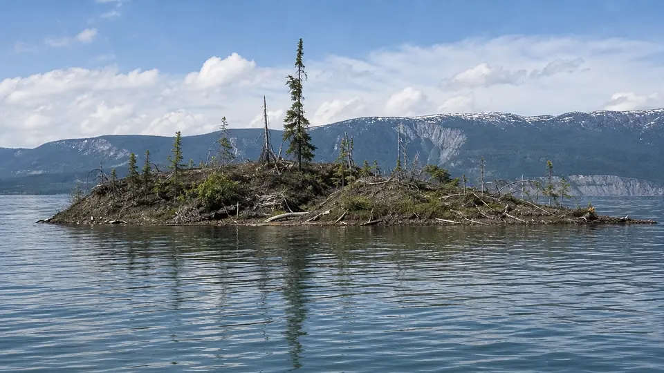
A floating forested island nearly 150 metres long appeared on Williston Lake in British Columbia, vanished within days, and then reappeared on Monday roughly 20 miles from its original position.
Why it matters
BC Hydro has warned boaters to keep away from the island, describing it as very unsafe and very unstable, with footage showing trees shifting on a delicate, thin layer of logs.
A floating island thick with trees appeared without warning on Williston Lake in western Canada in August, startling local residents and confounding the officials responsible for managing the reservoir. Nearly 150 metres long and 75 metres wide, the land mass was not marked on any maps or navigation charts. Within days of its first sighting it had gone. On Monday, it reappeared — roughly 20 miles from its original position — in what BC Hydro, the government-owned utility that operates the dam and reservoir, described as "quite something and rather unbelievable".
An artificial lake with a singular history
Williston Lake is the largest body of freshwater in British Columbia, covering nearly 1,700 square kilometres. It is a reservoir, created when the W.A.C. Bennett dam flooded the region in the early 1970s. Its remote, expansive character meant the island — uncharted and unexpected — went unnoticed until a boater filmed it from the water, capturing close to a hundred trees undulating in the chop. Rocky Avery, a longtime local resident and friend of the boater, posted the footage to social media primarily to warn others of a potential navigational hazard. The clip swiftly generated widespread public interest.
BC Hydro's explanation
Bob Gammer, a spokesperson for BC Hydro, told reporters that when he first saw the images he required additional verification before accepting them as genuine. "In the days of AI, you really needed another form of verification or evidence like a corroborating eyewitness account," he said. Satellite imagery subsequently confirmed the island was real and floating in the main body of the reservoir, roughly 60 miles west of the dam.
BC Hydro believes the island is the product of years of trees and plants growing largely undisturbed on woody debris along sheltered sections of the reservoir's shoreline. The reservoir is currently at its highest level in 14 years, a consequence of high winter snowpacks and consistent summer rains that have raised water levels across the Peace River system. Gammer likened the growing conditions to hydroponics: "Well-fed trees growing on a decaying food source with lots of water … they could grow pretty quick." He added that the elevated water level had created "all of the right conditions to potentially lift this kind of little island from where it was, and bring it out into open water."
Between sightings, BC Hydro suggested the island may simply have drifted back to a sheltered stretch of shoreline. "It doesn't mean it's gone to the bottom of the reservoir," Gammer previously told CBC. The company does not know the age of the trees, though local residents speculated they could be decades old. With the right conditions, Gammer said, the forest could "just stay there for years" and continue to grow.
Wildlife and a safety caution
Measuring roughly 12,000 square metres, the island is home to birds and small animals living among a mix of coniferous and broadleaf trees. Observers believe the root system submerged beneath the surface shelters some of the lake's best fish. Similar floating islands have been recorded elsewhere; BC Hydro cited Wisconsin's Forty Acre Bog on Lake Chippewa, a structure knitted together by peat, mud, roots and trees, as a comparable phenomenon.
Despite the curiosity the island has generated, Gammer urged boaters to keep their distance. Footage shows the trees moving back and forth on what he described as a "delicate, thin layer of logs", making the surface "very unsafe" and "very unstable". Avery himself said he would readily set foot on it were it possible, speculating that the large trees at the centre might support a person's weight, while acknowledging that the outer sections were likely shaky. The caution from BC Hydro, however, was unambiguous.
Avery's social media posts prompted not only safety discussion but a sardonic political undercurrent. With the US president, Donald Trump, having recently chosen to rename Lake Ontario following the collapse of trade talks between the two countries — a move that drew anger and mockery from the Canadian public — commenters were quick to note that the unnamed floating island represented an opportunity. "I'm surprised Trump hasn't named [the island] and claimed it," wrote one user beneath Avery's post.
Topics
People
Organizations
Places
Source: The Guardian